Recently, the Group of Satellite Navigation and Remote Sensing, led by Prof. Shuanggen Jin from Shanghai Astronomical Observatory, Chinese Academy of Sciences, investigated seasonal signals by the Earth’s surface loads using space geodetic observations. They studied displacements from Global Navigation Satellite System (GNSS) and time-variable gravity from Gravity Recovery and Climate Experiment (GRACE) to extract signals of surface loads such as terrestrial hydrological loads and snowpacks, and explored their geophysical application. Various results indicated that space geodesy offers an effective method to study surface loads and crustal movements caused by them. Relevant results have been published in the journal Satellite Navigation on July 24, 2023.
In early days, displacements generated by surface loads were considered as a noise disturbing the tectonic motion signals. In 1990s, geodesists started observing crustal movements precisely with high spatial and temporal resolution using dense networks of continuous GNSS receiving stations. They found significant seasonal signals overprinted to secular tectonic movements, and such seasonal signals gradually drew their attentions. For example, Professor Heki, one of authors, analyzed GNSS data in northeastern Japan and found that the east-west crustal shortening and extension occurred in winter in the western and eastern sides of the Northeast Honshu backbone range, respectively. This let him hypothesize that those signals come from snow loads on the western flank of the range [1]. The launch of the GRACE satellites in 2002 enabled us to directly observe mass anomalies on the Earth from space, and the combination of the GRACE and GNSS observations contributed to make surface load studies more convincing. The team studied seasonal (periodic) and intra-seasonal crustal movements by analyzing surface displacement data from GNSS and mass anomalies from GRACE to investigate, e.g., changes in the Earth’s dynamic oblateness [2], global time-variable gravity fields [3], extreme droughts in the Southwest United States [4], and water load by disastrous heavy rains in Japan [5].
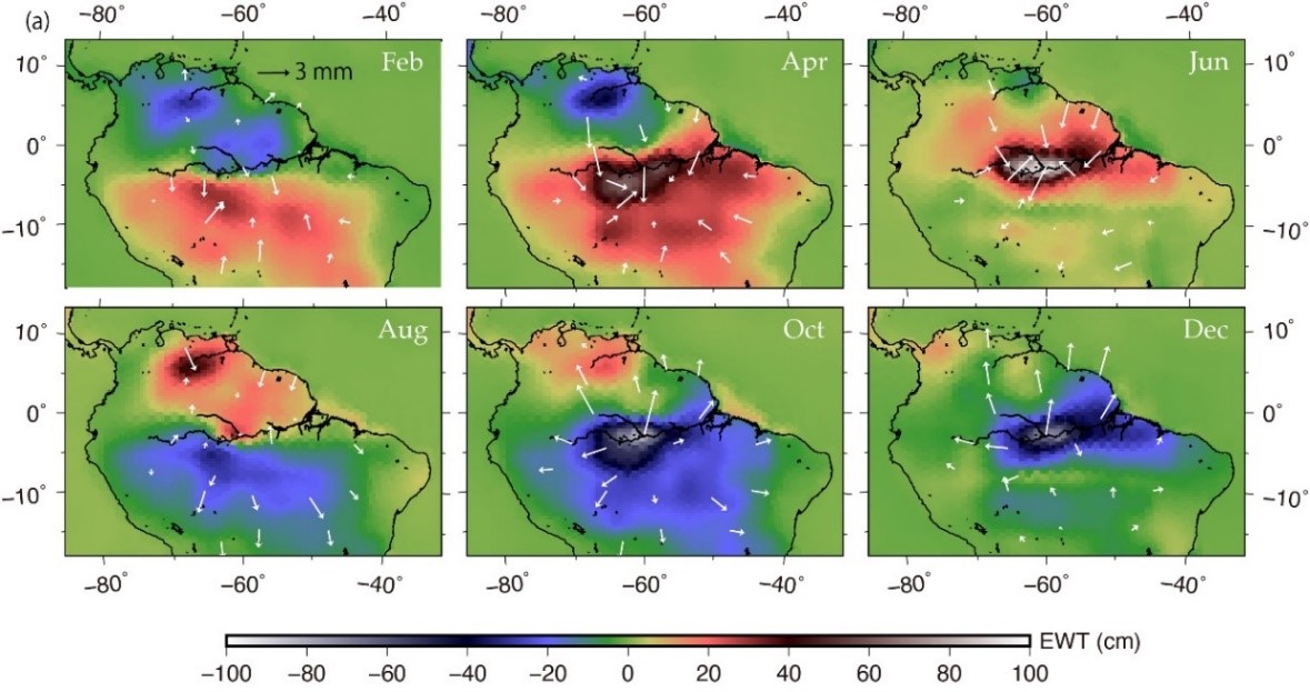
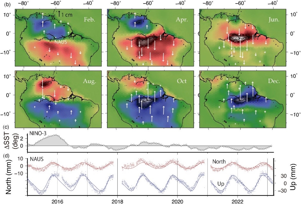
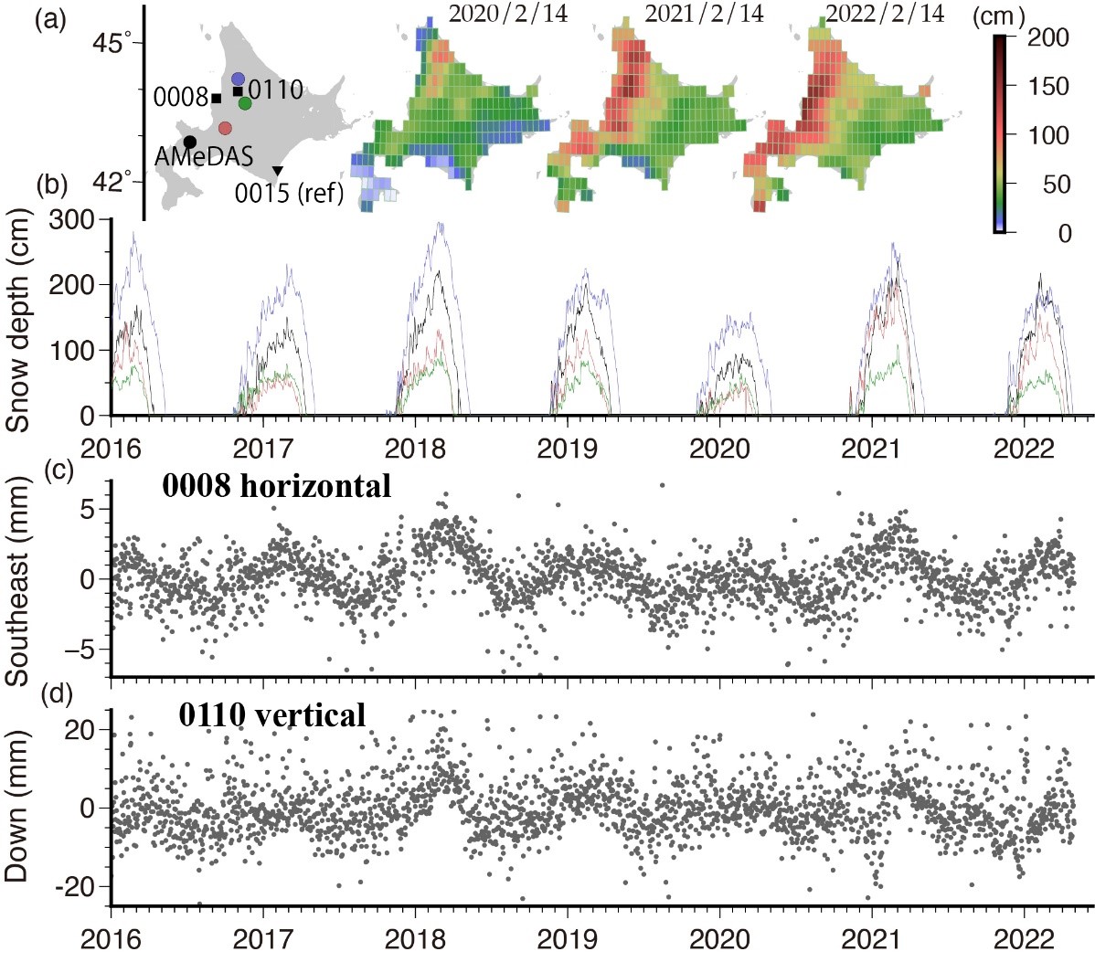
This study includes a figure showing the displacements of GNSS stations and the mass anomalies from GRACE in northern South America (Fig. 1). They show seasonal changes in land hydrological loads characterized by alternation of rainy and dry seasons near the equator. There, horizontal and vertical displacements show different spatial distributions. Vertical displacement is the largest at the center of the load, while the largest horizontal displacement occurs along the edge of the load. In other words, horizontal displacements reflect azimuthal asymmetries of the ambient loads rather than the load at that point. Fig. 2 shows the surface displacements in Hokkaido, northern Japan, caused by snow loads. The amount of snow shows significant interannual variations (Fig. 2a,b), and amplitudes of seasonal crustal movements (Fig. 2c, d) well reflect such variations.
Displacements and mass anomalies from GNSS and GRACE provide complementary information on seasonal change of surface loads, such as terrestrial hydrological loads as shown in Figs. 1 and 2. Prof. Heki, one of the authors, said shat due to the different spatial resolutions of the two techniques, displacements and mass anomalies are often inconsistent with each other when surface loads are composed of complex small-scale anomalies. This will be a key direction of future geodetic investigations of surface loads. Prof. Shuanggen Jin, the other author, said that we had obtained tools to study monthly global gravity fields and high time and space resolution displacement fields and such space geodetic techniques will be important for monitoring disastrous floods and droughts.
This study was supported by the President’s International Fellowship Initiative of the Chinese Academy of Sciences and the Strategic Priority Research Program Project of the Chinese Academy of Sciences
Fig. 1. Average horizontal (a) and vertical (b) displacements (GNSS) and mass anomalies (GRACE) in northern South America. (d) The time series of horizontal (red) and vertical (blue) displacements of NAUS station in the middle of the Amazon Basin are shown together with average seasonal (annual and semiannual) change curves. During an ENSO episode in 2015-2016 (c), abnormally small rain made NAUS uplift more than other years.
Fig. 2. Seasonal crustal movements by snow loading in Hokkaido, northern Japan. (a) Vertical displacements in winters of 2020, 2021 and 2022 in Hokkaido. (b) Snow depth curves at four AMeDAS (Automatic meteorological data acquisition system). (c) Horizontal displacement of a northwestern coastal station (0008) toward southeast (N135E) relative to a reference station in southeast (0015). (d) Time series of down component at a station within a deep snow area (0110).
References:
[1] Heki, K. (2001). Seasonal modulation of interseismic strain build-up in Northeastern Japan driven by snow loads. Science, 293, 89-92.
[2] Jin, S.G., & Zhang, X.G. (2012). Variations and geophysical excitation of Earth's dynamic oblateness estimated from GPS, OBP, and GRACE. Chin. Sci. Bull., 57(36), 3484-3492, doi: 10.1360/972011-1934.
[3] Zhang, X., Jin, S.G., & Lu, X. (2017). Global surface mass variations from continuous GPS observations and satellite altimetry data. Remote Sens., 9(10), 1000, doi: 10.3390/rs9101000.
[4] Jin, S.G., & Zhang, T.Y. (2016). Terrestrial water storage anomalies associated with drought in Southwestern USA derived from GPS observations. Surv. Geophys., 37(6), 1139-1156, doi: 10.1007/s10712-016-9385-z.
[5] Heki, K., & Arief, S. (2022). Crustal response to heavy rains in Southwest Japan 2017-2020. Earth Planet. Sci. Lett., 578, 117325, doi: 10.1016/j.epsl.2021.117325.
Scientific Contact:
Prof. Shuanggen Jin, Shanghai Astronomical Observatory, Chinese Academy of Sciences, Email: sgjin@shao.ac.cn